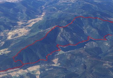
![](/images/other/stat-length.png)
![Trail Walking La Môle - Sentier de l'hermitage - Photo](https://media.geolcdn.com/t/1900/400/333aac1f-a695-4a6b-8e7f-0242a53c2a36.jpg&format=pjpeg&maxdim=2)
Sentier de l'hermitage
ETMU5496
User
![Length](/images/other/stat-length.png)
![Max alt](https://static1.geolcdn.com/siteimages/upload/files/1508320355ic_sort_altitude_max_24dp.png)
![Uphill gradient](https://static1.geolcdn.com/siteimages/upload/files/1508320355ic_sort_den_pos_24dp.png)
![Km-Effort](/images/other/stat-length.png)
![Min alt](https://static1.geolcdn.com/siteimages/upload/files/1508320355ic_sort_altitude_min_24dp.png)
![Downhill gradient](https://static1.geolcdn.com/siteimages/upload/files/1508320355ic_sort_den_neg_24dp.png)
![Boucle](https://static1.geolcdn.com/siteimages/upload/files/16400158638029165_repeat_loop_refresh_sync_direction_icon.png)
![Walking](https://static1.geolcdn.com/sitytour/trail-icons/101.png)
5h48
Difficulty : Medium
![Scan this QR Code to open this trail in the SityTrail application](https://capi.geolives.com/qq0zvz2zws4bq2lad0pu/sitytour/trails/2257215/qr.png?size=200)
FREE GPS app for hiking
About
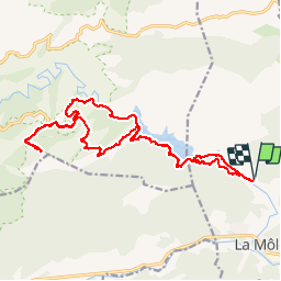
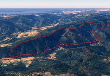
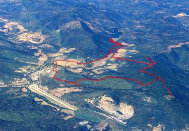
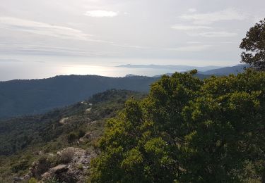
Trail Walking of 22 km to be discovered at Provence-Alpes-Côte d'Azur, Var, La Môle. This trail is proposed by ETMU5496.
Description
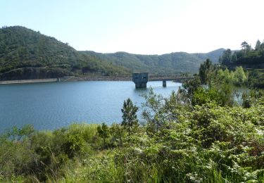
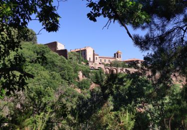
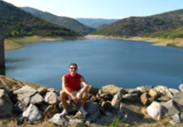
Une jolie randonnée sans grande difficulté au départ de la Môle; longeant le barrage de la Verne. Puis ascension vers la Chartreuse de la Verne que l'on laisse sur la droite.
Poursuivre par une petite piste dans la forêt avant d'atteindre un sentier plus raide et assez sauvage. Au final, arrivée au lieu dit l'Hermitage.
Après le pique-nique au sommet, redescendre le même sentier jusqu'à la Chartreuse et même au delà jusqu'à une bifurcation à droite pour un sentier alternatif qui mènera à la piste principale près de la pièce d'eau du barrage. Près de 23 km au final et un dénivelé moyen.
Positioning
Comments
Trails nearby
![Trail Walking La Môle - SityTrail - Barrage de la verne - Sommet de l'Argentière par les crêtes des Pradets - Retour par le bord du lac - Photo](https://media.geolcdn.com/t/375/260/760c7a83-a4d8-41d7-9ea7-3093b4adef8e.jpg&format=jpg&maxdim=2)
![Walking Walking](https://static1.geolcdn.com/sitytour/trail-icons/101.png)
Walking
![](/images/other/stat-length.png)
![](https://static1.geolcdn.com/siteimages/upload/files/16400158638029165_repeat_loop_refresh_sync_direction_icon.png)
![Trail Walking La Môle - SityTrail - SityTrail - la mole - Photo](https://media.geolcdn.com/t/375/260/0ba0349d-6bb2-4249-b45a-746244491cb5.jpg&format=jpg&maxdim=2)
![Walking Walking](https://static1.geolcdn.com/sitytour/trail-icons/101.png)
Walking
![](/images/other/stat-length.png)
![](https://static1.geolcdn.com/siteimages/upload/files/16400158638029165_repeat_loop_refresh_sync_direction_icon.png)
![Trail Mountain bike Cogolin - peinier - Photo](https://media.geolcdn.com/t/375/260/ext.jpg?maxdim=2&url=https%3A%2F%2Fservices.sitytrail.com%2FGeolivesWS%2FDownloadMedia.ashx%3FTrailID%3D137318%26Media%3D20120704191905.jpeg)
![Mountain bike Mountain bike](https://static1.geolcdn.com/sitytour/trail-icons/202.png)
Mountain bike
![](/images/other/stat-length.png)
![](https://static1.geolcdn.com/siteimages/upload/files/16400158638029165_repeat_loop_refresh_sync_direction_icon.png)
![Trail Walking La Môle - Rando Chartreuse de la Verne - Photo](https://media.geolcdn.com/t/375/260/ext.jpg?maxdim=2&url=https%3A%2F%2Fservices.sitytrail.com%2FGeolivesWS%2FDownloadMedia.ashx%3FTrailID%3D103792%26Media%3D6562_1.jpg)
![Walking Walking](https://static1.geolcdn.com/sitytour/trail-icons/101.png)
Walking
![](/images/other/stat-length.png)
![](https://static1.geolcdn.com/siteimages/upload/files/16400158638029165_repeat_loop_refresh_sync_direction_icon.png)
![Trail Walking La Môle - Barrage de la verne - Sommet de l'Argentière par les crêtes des Pradets - Retour par le bord du lac (V1) - Photo](https://media.geolcdn.com/t/375/260/84190798-1374-481e-8920-bdcbb144aaf2.jpg&format=jpg&maxdim=2)
![Walking Walking](https://static1.geolcdn.com/sitytour/trail-icons/101.png)
Walking
![](/images/other/stat-length.png)
![](https://static1.geolcdn.com/siteimages/upload/files/16400158638029165_repeat_loop_refresh_sync_direction_icon.png)
![Trail Mountain bike La Môle - VTT - La Mole - Barrage de La Verne - Chartreuse de La Verne - Capelude - Retour La Mole par les crêtes - Photo](https://media.geolcdn.com/t/375/260/977ec82e-6359-4a66-ab94-b782942b304d.jpg&format=jpg&maxdim=2)
![Mountain bike Mountain bike](https://static1.geolcdn.com/sitytour/trail-icons/202.png)
Mountain bike
![](/images/other/stat-length.png)
![](https://static1.geolcdn.com/siteimages/upload/files/16400158638029165_repeat_loop_refresh_sync_direction_icon.png)
![Trail Walking Cavalaire-sur-Mer - LES TERRASSES DE CAVALAIRE - MONTJEAN ET LES PRADELS - Photo](https://media.geolcdn.com/t/375/260/5f48f092-4ed2-4897-8c27-3de5ff3811f4.jpg&format=jpg&maxdim=2)
![Walking Walking](https://static1.geolcdn.com/sitytour/trail-icons/101.png)
Walking
![](/images/other/stat-length.png)
![](https://static1.geolcdn.com/siteimages/upload/files/16400158638029165_repeat_loop_refresh_sync_direction_icon.png)
![Trail Mountain bike Cogolin - Cap Taillat - Photo](https://media.geolcdn.com/t/375/260/ext.jpg?maxdim=2&url=https%3A%2F%2Fstatic1.geolcdn.com%2Fsiteimages%2Fupload%2Ffiles%2F1524743154velo.jpg)
![Mountain bike Mountain bike](https://static1.geolcdn.com/sitytour/trail-icons/202.png)
Mountain bike
![](/images/other/stat-length.png)
![](https://static1.geolcdn.com/siteimages/upload/files/16400158638029165_repeat_loop_refresh_sync_direction_icon.png)
![Trail Mountain bike La Môle - Autour du barrage de la Verne - Photo](https://media.geolcdn.com/t/375/260/ext.jpg?maxdim=2&url=https%3A%2F%2Fservices.sitytrail.com%2FGeolivesWS%2FDownloadMedia.ashx%3FTrailID%3D102976%26Media%3D4461_3.jpg)
![Mountain bike Mountain bike](https://static1.geolcdn.com/sitytour/trail-icons/202.png)
Mountain bike
![](/images/other/stat-length.png)
![](https://static1.geolcdn.com/siteimages/upload/files/16400158638029165_repeat_loop_refresh_sync_direction_icon.png)